The region’s location next to the Atlantic Ocean and in the intermediate part of Galicia places Costa da Morte in the Eurosiberian floral region, which extends through the centre and north of Europe and determines the type of vegetation. At the same time, the region is also influenced by other factors local to this western region, such as the Atlantic climate and the mostly acidic soil.
Oak forests are the local most common woodland to be found throughout the region, although intense human activity over many years have led to these natural woodlands practically disappearing in some areas. Now their presence is limited to river banks where, along with other tree species such as alder, ash, willow, birch, hazel, laurel and hawthorn, form what is called a riverside woodland.
The spaces once occupied by oak forests were initially replaced by gorse and heather. Species for forest repopulation such as pines and eucalyptus were then planted and now cover most of the surface area of the local hills and mountains, and in some cases have invaded farmland. However, a trip through Costa da Morte is not just countryside dominated by trees, it contains other very different landscapes, both on the coast and further inland.
The extensive coastal region has a wide range of fascinating natural spaces with specific flora and fauna that come together to create a unique landscape.
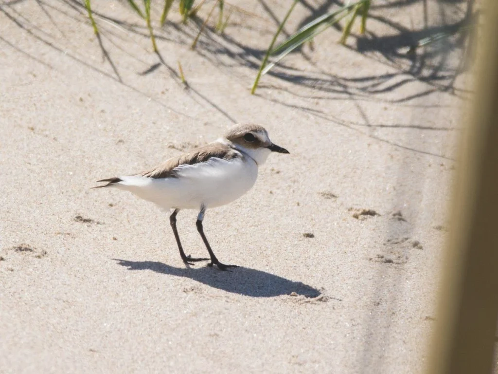
There are vast sandy areas with dunes, wetlands and even the occasional coastal lagoon, where there is a remarkable diversity of flora and fauna, as is the case with Razo and Baldaio in the municipality of Carballo, a fascinating natural space with different ecosystems: beach, dunes, wetlands and a lagoon. One very notable feature of the area is the wealth of bird life, especially water birds. One of the best known and most endangered species is the Kentish plover (Charadrius alexandrinus), which nests on top of the dunes.
The next natural area with extensive sands and a coastal lagoon is the beach of Traba de Laxe, an area that also blends in with the surroundings hills, the famous crags of Pasarela and Traba, which were declared a Natural Landscape in 2009 for their considerable geological and scenic value.
Two different ecosystems exist in this natural coastal setting: the beach, and the dunes and coastal lagoon. Each one has its own particular fauna. The plant species in the area include the Centaurea corcubionensis, which is endemic to this coast.
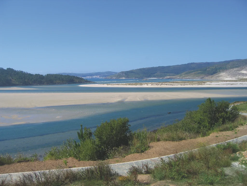
The last large sandy area is the beach of Carnota, with dunes and wetlands. This 7 km stretch of sand is the longest in Galicia. The beach itself is of fine white sand produced by erosion of the local granite and seashells. The variety of flora and fauna throughout the area also makes it a site of great natural interest.
These extensive areas of sand alternate with long sections of cliffs, especially in the contours of the peninsulas and promontories that form the capes and headlands, where winds blow fiercely and waves break with force against the rocks.
There is little in the way of woodland in the coastal areas because of the tough environmental conditions. What is commonly found in these areas is low vegetation, such as gorse and heather, as can be seen on the coast between Razo and Malpica, at the cape of Santo Adrián and the Sisargas Islands, the peninsula of Roncudo, the coast from Camelle to cape Vilán, the peninsulas that form the headlands of Buítra and cape Touriñán, cape of A Nave and cape Fisterra.
The third and last group of coastal spaces of natural interest are the estuaries of the largest local rivers: the rivers Anllóns, Porto, Castro and Xallas and the rías that they flow into are more protected than the rest of the coast and have a wide variety of flora and fauna.
The estuary of the river Anllóns, also called the cove of Insua, is the last stretch of the river, extending from the bridge at Ponteceso to A Barra. The estuary is a large natural space enclosed by a sandbank where a dune was formed that covered the southern slope of Monte Branco because of the winds. The areas of mud and the wetlands that surround it contain a rich variety of flora and fauna typical of these types of ecosystems. An outstanding feature is the large number of aquatic birds that use the area as their permanent or temporary habitat. They have been catalogued by the renowned ornithologist José Luis Rabuñal Patiño in his many visits to this area.
The estuary of the river Porto commences at the bridge of Ponte do Porto, where the river broadens. The river flows more slowly after Baixa de Dor and forms small islets that some local aquatic birds use for nesting.
In the final stretch, sand begins to form on the margins of the river to create the beaches of Ariño near Xaviña and Area Grande near Leis. The advantage of this estuary is that, from Cereixo up to its end point at the ría of Camariñas, its banks are covered with vegetation and no man-made structures are present, and so human intervention is scarce, making it a very safe and peaceful location for the local fauna.
The mouth of the river Castro forms a very small estuary that was modified by the Tres Mares fish farm, built here in 1969 to breed trout. This space, through the mouth of the river Lires, forms an area where a large number of aquatic birds mingle and breed, an ideal place for bird watchers.
The river Xallas, the mouth of which forms a large waterfall, has a small estuary at the foot of Monte Pindo where the waters flow into the ría of Corcubión. The right-hand side of the estuary and the fauna that inhabits the area have been greatly affected by human intervention in the form of a hydroelectric power plant and the houses of Ézaro that were built along the banks. The greatest natural attraction of the area is the unique granite enclave that surrounds the impressive waterfall of the river Xallas.
All these natural spaces have been under official protection for some years, and so should be treated with care and respect to ensure that they are not affected in any way.
The coastal areas of this region are included in the Natura 2000 network via the Special Conservation Zone (ZEC) of Costa da Morte, which includes the coast that extends from Sabón (Arteixo) to Fisterra, in a surface area of 11,809 hectares, and the ZEC of Carnota – Monte Pindo, which includes the last part of the river Xallas, Monte Pindo, the beach and wetlands of Carnota and the Lobeiras Islands, with a surface area of 4,628 hectares.
The wealth of bird life in some of these coastal areas has caused them to be protected as a Zone of Special Protection for Birds (ZEPA) of Costa da Morte, with a surface area of 7,962 hectares.
The sites of natural interest further inland in Costa da Morte include areas such as the ZEC of the river Anllóns, as part of the Natura 2000 network, which covers most of the main course of the river and its tributary, the Rosende, over a surface are of 162 hectares, as well as the Protected Landscape of the crags of Pasarela and Traba, with a surface area of 212 hectares in the municipalities of Vimianzo and Laxe.