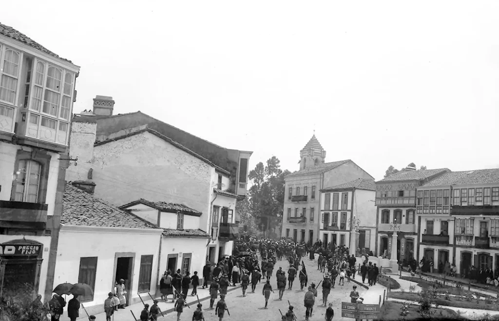
This fourth route takes in the northern part of the region of Bergantiños, where you’ll visit the most emblematic locations of the municipalities of Coristanco, Carballo and A Laracha.
This route is a circular one and so you can start from any point you like. Our proposal is to start in Malpica because it’s the town where the previous route ended.
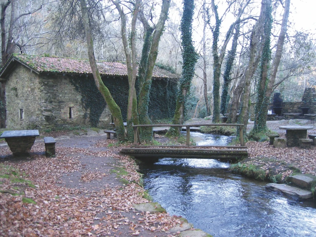
Leave Malpica on the AC-418 motorway in the direction of Carballo. When you come to the Buño roundabout, turn towards this village to take the AC 421 from Buño to A Agualada. Go through Xornes and cross the river Anllóns in A Pontedona. When you come to Cereo Vello, turn left towards Verdes, to visit the Refuxio de Verdes, your first stop. Here the Anllóns, the main river in the region of Bergantiños, creates a natural space of extraordinary beauty.
What began as (and still is) a refuge for anglers became the best leisure area in the region. Its origins go back to the important fishing reserve in this section of the Anllóns, one of the best in the entire province of A Coruña.
In 1982, the National Institute for Nature Conservation (ICONA), purchased the mills that now function as refuges, and started to build the leisure area. The residents of Verdes actively collaborated in the project. A bridge was built to provide access to the island where the refuge is. The large mill with three millstones and two smalls mills were restored, the mill races were cleared and cleaned, and several wooden bridges and tables in the open air were installed. The leisure area has grown over time, with increased capacity for a growing number of visitors.
The Anllóns in Verdes has created a natural space that combines a unique area of study for anyone interested in geology, botany or ethnography, or for anyone who simply wants to spend their free time in a beautiful place.
The geology of the area is interesting because of the rocks in this part of the river.
The stone in Verdes is gneiss, a hard metamorphic rock made up of bands of quartz, feldspar and mica. Gneiss is very resistant to erosion, so the river could not easily form a bed and was forced to spread the flow out into several streams. The erosive action of the river was encouraged by the local tectonics, which created an uneven flow and led to rapids and waterfalls. Natural pools formed in the river bed are common in this area, and some of them are quite large.
The interest of the local botany lies mainly in the beautiful riverside woodland that flourishes in the area. Eduardo Pondal mentions the oakwood of Verdes in his poetry, some of which is still preserved and called the chousa da Señora. The forest consists mainly of oak, alder, willow, ash, bay and hawthorn.
As regards the fauna, the fishing reserve of Verdes was one of the most famous in the province of A Coruña because of the quantity and quality of the trout that was caught here. The pollution caused serious damage to the river fauna. The situation has improved in recent years, but a major effort will need to be made if the Anllóns is to recover the wildlife that used to be here.
The ethnographic interest of the area revolves around the mills that were built here. Most of them consist of one simple building made of the abundant local gneiss. The larger mills had a fireplace to keep the winter chills at bay and an attic to sleep at night.
Most of the mills are now in ruins, apart from the ones that have been restored as refuges and others that still conserve their walls and roof.
Refuxio de Verdes is an ideal place to take a walk and enjoy the peace and quiet in a beautiful natural setting. It’s also an excellent place for family and friends to get together and spend an unforgettable day.
Take the CP 1910 road from Verdes that passes through Xaviña and Oca, and links up with the AC 552 in Montecelo. Head towards Carballo, when you cross the viaduct for the exit of the AG 55 motorway, take the lane on the right that goes to the Ponte Lubián bridge, also known as Ponte Romana (the Roman Bridge), built on the river Lubián, which is the largest tributary of the Anllóns. The old royal road that went from A Coruña to the regions of Soneira and Fisterra crossed over this bridge. According to Carré Aldao, the Roman road called per loca maritima passed through here, but there is no evidence to support this assertion. In any case the ancient road would not have passed over this bridge, which dates from the late Middle Ages or even later. Salvador Parga Pondal visited the bridge in 1948 and said that it looked medieval, although the westernmost arch shows signs of Roman construction..
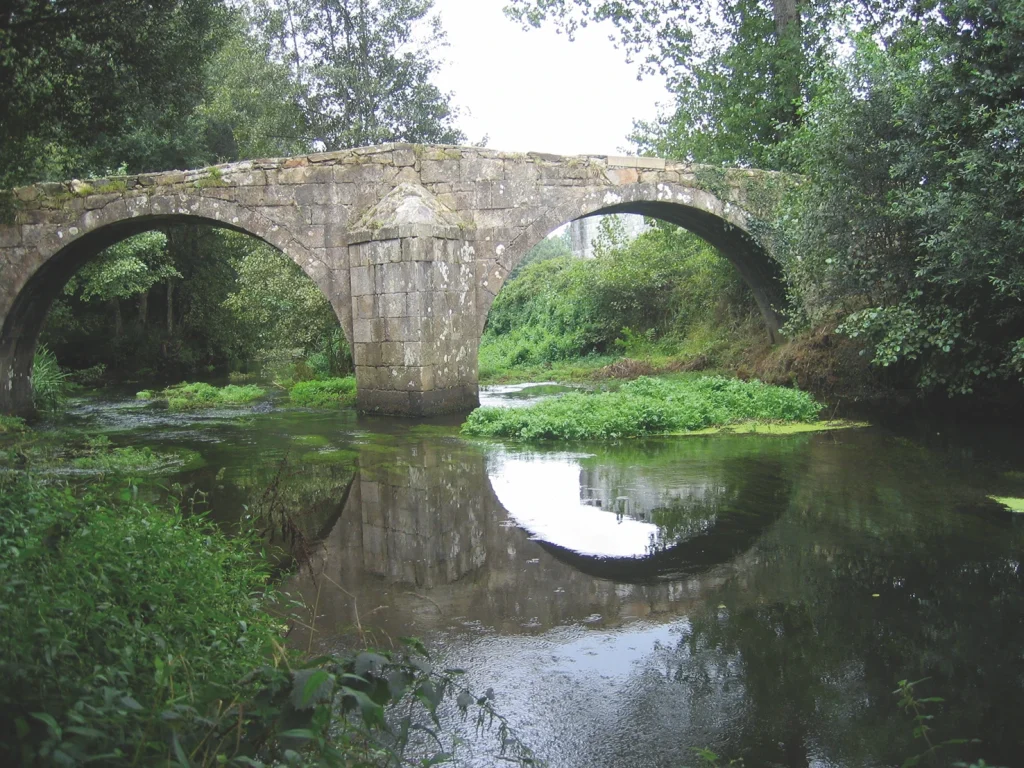
The fact that it is not a Roman monument does not mean that it lacks tremendous historical and artistic value that is well worth preserving. It is now the most valuable remnant of the old roadways in the region of Bergantiños. The structure itself is approximately 40 m long and 2.60 m wide. It has four asymmetric arches: the two on the right end side are larger than the other two at the other end. There is a cutwater between the largest arches and a circular buttress on the other side to reinforce the structure. The road over the bridge is made of stone slabs that extend some metres beyond and form a ridge that reaches its maximum height at the pillar supported by the two larger arches. Go back along the track and head off towards Carballo.