Continue with the route from O Pindo to the south along the road bordering the coast. Pass through the villages of Quilmas and Caldebarcos. From here on the road circles the wetlands of Caldebarcos, which were formed at the mouth of the river Vadebois, a natural space of great ecological interest, where the immense beach of Carnota starts on its 7 km journey to the headland of Os Remedios. The beach has different names according the places nearby: Caldebarcos, San Mamede, Carnota, O Cancelo and O Mar de Lira.
Before you arrive at O Viso, there is a diversion to the left that takes you to the hamlet of Cornido (1.7 km) and the workshop of the ceramicist Nacho Porto, a leading figure in the craft in Galicia.
The road passes through the narrow plain of the valley of Carnota. After passing through the hamlets of O Viso and Pedrafigueira, you arrive at Carnota, the capital of the municipality
This coastal strip of alluvial land is excellent for farming. It was once part of the ancient Commiso (county) of Cornatum, donated by king Ordoño III in the mid-10th c. to the archbishop of Santiago, Sisnando II, and later owned by several feudal families: The Trabas, Trastámaras and the Condes de Lemos.
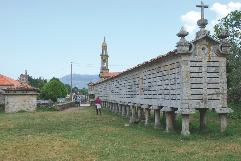
Carnota is worth stopping off at to see the huge hórreo, or corn granary, which, combined with the rector’s house and church, make for an interesting architectural complex.
The hórreo was designed by the architect Gregorio Quintela, who wanted to give an artistic touch to a purely functional structure, and so engraved his name and the date of completion on the granary. It was built in two phases. The first part was built in 1768 and measured 17 metres, and the second part of the same length was added in 1783.
The architect gave a Baroque feel to the structure, which can be seen in the overhangs of the gables, the finials at the ends, and the cross. A touch of ostentation can also be seen in the louvres, the saddle stones and the feet that support the structure.
The rector’s house and a dovecote can be seen next close to the hórreo. To the north is the parish church of Santa Comba, a Baroque building with a ground plan of a Latin cross and three naves. It was built in 1755. The interior contains an interesting Neoclassical main altarpiece, made by the sculptor José Ferreiro. The slender bell tower dates from the 19th c.
The parish of Santa María de Lira lies to the south of Carnota. The village has another large hórreo, with two feet less than the one in Carnota, but is longer overall. It stands on a stone platform and was built in the same period as the one in Carnota.
Once you pass through the parish of Santa María, there is a diversion to the right (point km 12), that takes you to the small port of Lira, which is also called Portocubelo, where you can see the fish auction hall, the boats and a small museum with some traditional fishing tackle on display.
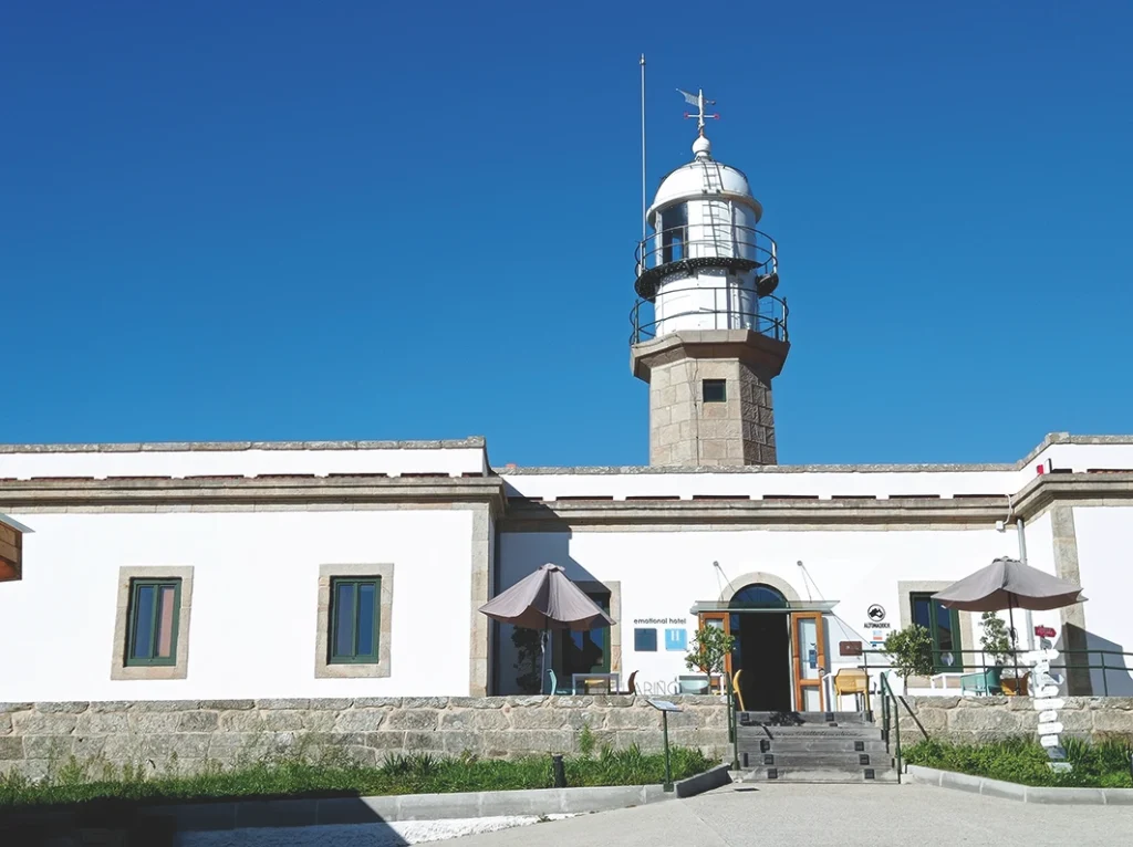
Lighthouse of Lariño
After passing through Lira, you enter the parish of Lariño, the last one in the municipality of Carnota. Watch out for point km 9, where there is a track on the right that takes you to the Punta da Insua where the lighthouse is. The building is rough-coated and painted white, and was designed by the engineer Salvador López Miño. Alongside is a 14 m high octagonal tower crowned by a dome with a wind vane dated 1920. Building work was completed in 1913, but it took several years for it to enter into service (1921). The reason for installing a lighthouse here was to warn of a long section of hazardous coast between cape Fisterra and cape Corrubedo. The lighthouse facilities were refurbished and converted into a hotel in summer 2021.
This area of A Insua witnessed the sinking of the Ariete, a vessel of the Spanish navy, which was driven against the sandbanks here on 25 February 1966. There were 190 crew members on board, who were saved thanks to the intervention of the people of Carnota. To thank the residents, many of them were decorated and the municipality of Carnota received a plaque with the inscription “Most humanitarian town”.
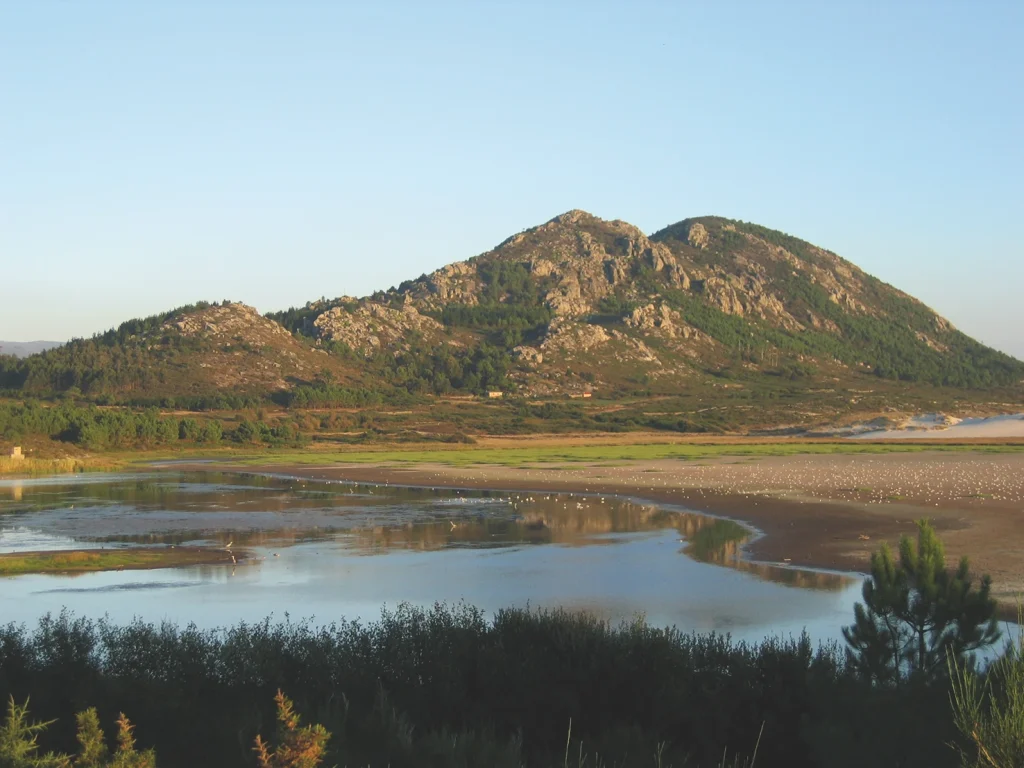
Head back from the Punta da Insua to the main road and continue towards Muros. Before you reach the town, you’ll see Monte Louro on your right, a granite peak that rises up to 241 m and stands out from the surrounding landscape for being so close to the sea. You then pass close to the lagoon of As Xarfas, a coastal lagoon that was formed by the dunes of the beach Maior, which stopped the waters of the stream of Longarelo from flowing into the sea. The beach, dunes and lagoon combine to make a very interesting natural space. Then you’ll pass through the tourist village of San Francisco in the parish of Louro, whose name comes from a medieval monastery that was once here. Your next stop is the town of Muros.